 Montour Railroad
|
|
Jean Mine Here is Bob Ciminel's report on the Jean Mine Jean Mine was a relatively small operation the opened sometime between 1917 and 1920. It was located south of the Montour tracks between Clinton Block Junction and North Star Wye. There is very little information about the mine. The former mine site can be reached by taking Gene Mine Road off of U.S. Route 30 on the east side of the former Montour Railroad bridge at Imperial.The Jean Mine was located a short distance east (railroad) of Clinton Block Junction. There is little information about this mine, except that it was operating in 1920 and was owned by the Jean Coal Company of Crafton, PA. Pennsylvania corporate records show that a Jean Coal Company was chartered on July 19, 1918 with a capital of $65,000 and headquartered in Pittsburgh. To add to the confusion, there was also another Jean Mine located at Dinsmore, west of Burgettstown, on the Panhandle main line. This mine was owned by the Bertha Coal Company, which operated the large Bertha Mine in the same area. There are no production records for Jean Mine in the 1931 Pennsylvania Annual Bituminous Coal Report, indicating that the mine was abandoned sometime prior to then. Other records show that a Jean No. 2 Mine was operated by the North Star Coal Company in the same area in 1956. This may have been a strip mine. Another confusing fact associated with the Jean Mine is that current maps show the old mine site located at the end of “Gene Mine Road,” which appears to be the remnants of the original Montour Railroad right-of-way to North Star and the Partridge Mine. Aerial photos also show that the entrance to the mine, which is now a road, has a curve that appears to have been built to accommodate trains rather than automobiles. There is also the outline of what could have been a former siding next to the main track on the newer alignment the railroad took when it built the overgrade crossing at Route 30. The Pittsburgh seam at Jean Mine was 1,160 feet above sea level and the mine’s drift entry was at approximately 1,100 feet, making the mine self-draining. Jean does not appear to have been a large mine and abutted the Partridge Mine on the southwest and the Margerum/Montour mine on the northeast. This Google Earth image shows the former location of Jean Mine adjacent to the Montour Trail. The inaccurately named Gene Road comes in from the upper right and curves southeast to where the mine entries were located. 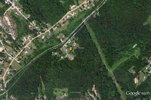 This 1906 topographic map shows the pre-1914 Montour Railroad terminating at the Partridge Mine in North Star (present day Santiago) and the 1,100-foot contour where Jean Mine penetrated the hill as it mined coal toward the southeast and under Steubenville Pike. 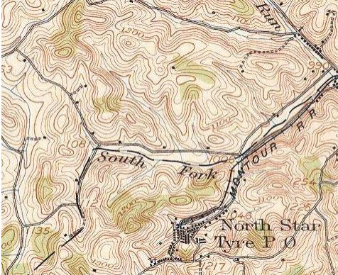 This most recent topographic map that pre-dates the Montour Railroad abandonment shows some of the houses along Gene Mine Road located between “Montour” and “Run.” The former rightof-way to the Clinton Block Spur is indicated by the straight hachured line where the bridge across the South Fork of Montour Run was located beneath the “l” in “Imperial.” These types of features are easy to locate on topographic maps based on the old adage that, “There are no straight lines in Nature.” 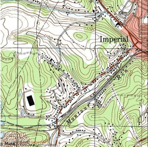 This excerpt from the WPA mine map shows the location of the mine labeled as “Jean Coal Co. Mine” between “Montour” and “R. R.” The road shown at lower right is Steubenville Pike. 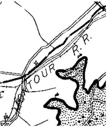 This excellent 1939 aerial photo shows the Montour Railroad bridge over Route 30 and the Clinton Block Spur bridge over the South Fork of Montour Run in the upper right. Jean Mine is at lower left with sinkholes in the abandoned workings showing at the tree line adjacent to the empty field on the east. There is also a line of sinkholes on the lower left. (photo from PennPilot) 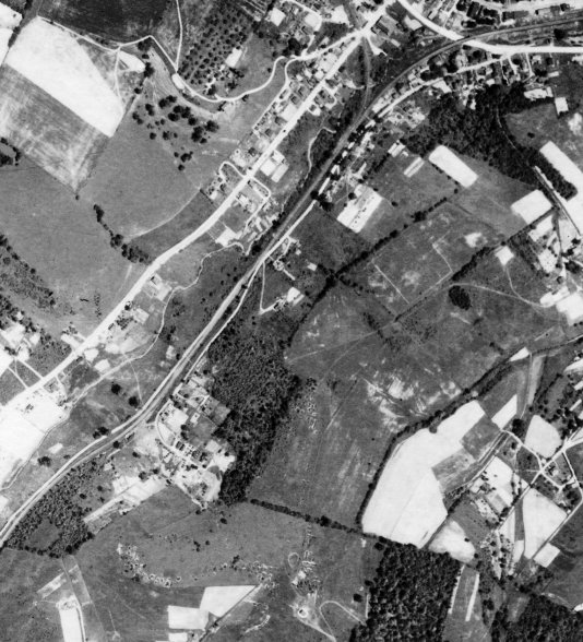 |
